

Although gravity is often assumed to be a constant, it actually varies depending where you are on Earth. Gravity is weaker near the equator due to the centrifugal forces of the planet spinning through space, it is lower at locations further from the Earth’s core like on mountain peaks. There’s also the fact the Earth isn’t a perfect sphere, nor uniformly dense.
(The lowest gravitational acceleration on the planet has been measured at Mount Nevado Huascaran in Peru while the highest is at the surface of the Arctic Ocean)
Gravity even changes from month to month due to the enormous mass of the oceans moving around the Earth’s surface.
That’s a major headache for civil engineering projects like tunnels and skyscrapers, which need the local gravity for precision measurements. It also makes it difficult for scientists trying to gain a picture of sea level changes and how these relate to water tables, ice sheets and climate change.
In 2002, NASA launched the Gravity Recovery and Climate Experiment (GRACE) mission, sending two identical car-sized satellites to space. A microwave ranging system monitored the distance between them to within a micron, allowing scientists to map gravity by measuring tiny changes in distance between the two satellites as each of them speeds up and slows down in response to gravitational force.
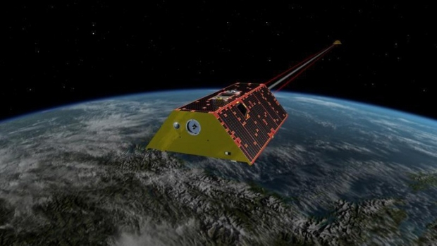
Those satellites stopped working last year. This morning two replacement satellites – the GRACE Follow-On (FO) mission – launched into space from Vandenberg Airforce Base in California aboard a Space X Falcon 9 rocket.
Instead of microwave ranging systems, these satellites carry a laser-based system developed by scientists from the Australian National University (ANU). The laser system is able to measure changes in their separation to the nearest micron – a thousandth of a millimetre – a tenth of the width of a human hair.
The GRACE FO satellites were developed by American, German and Australian scientists, with the Australian team – funded by a $4.7 million Australian Space Research Grant – led by ANU’s Professor Daniel Shaddock. ANU posted a video of the launch.
“This will be the first mission that shoots laser beams between space craft, to improve the measurement by a factor of 20. This is the same technology that we’re developing for the multi-billion dollar gravitational wave detector mission we’ll launch in around a decade,” Shaddock said.
“This can tell us about changes in sea level and it can give us a complete map of the melting of ice in Greenland or Antarctica, but it can also tell us how the ground water changes in the Murray Darling Basin from one month to the next,” he added.
NASA scientists used GRACE data to identify regional trends of freshwater movement, and combined that information with data from other satellites, climate models and precipitation measurements to determine the causes of major regional trends in freshwater storage. NASA has posted a video explaining freshwater trends that GRACE has idenitifed.
The satellites – part of a US-German led mission – fly around 220 kilometres apart after they deployed into orbit at around 6am this morning.
“An increase in mass on Earth will make gravity stronger, which will cause one satellite to accelerate, which changes the distance between them,” Shaddock said. “There are already other missions planned around Mars and other planets to map their mass.”
IDG News Service


Subscribers 0
Fans 0
Followers 0
Followers